
Chapter 8
Atmospheric Pressure and Altimetry
Since existing conditions in a real atmosphere are seldom standard, altitude indications on the altimeter are seldom actual or true altitudes. True altitude is the actual vertical distance above MSL. If an altimeter does not indicate true altitude, what does it indicate?
8.4.1.2 Indicated Altitude
Figure 8-10 shows the effect of mean temperature on the thickness of three columns of air. Pressures are equal at the bottoms and tops of the three layers. Since an altimeter is essentially an aneroid barometer, altitude indicated by the altimeter at the top of each column would be the same. To see this effect more clearly, see Figure 8-12. In the warm air column, a pilot would fly at an altitude that is higher than the indicated altitude. In the cold air column, the pilot would fly at an altitude lower than the indicated altitude.
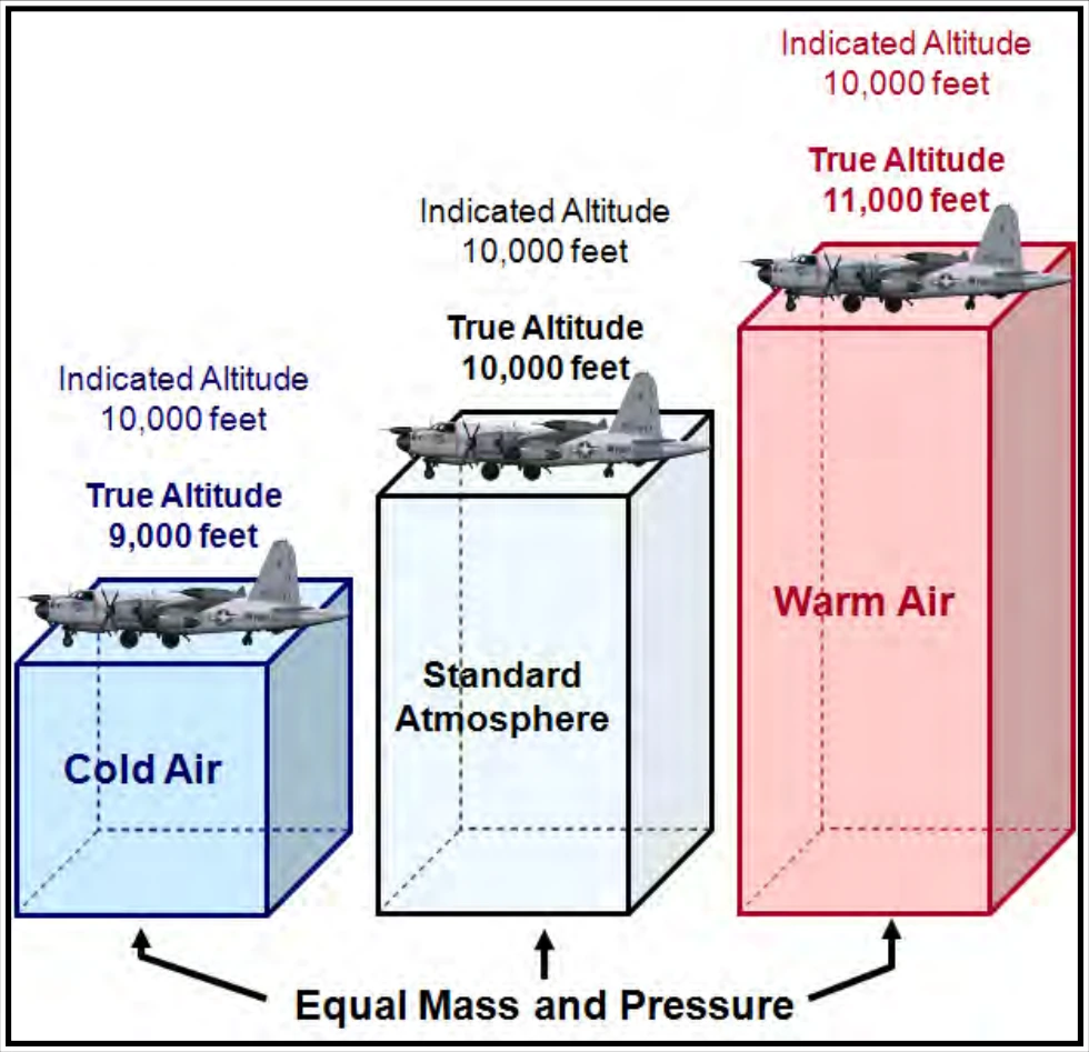
Height indicated on the altimeter also changes with changes in surface pressure. A movable scale on the altimeter permits the pilot to adjust for surface pressure, but the pilot has no means of adjusting the altimeter for mean temperature of the column of air below. Indicated altitude is the altitude above MSL indicated on the altimeter when set at the local altimeter setting. But what is altimeter setting?
8.4.1.2.1 Altimeter Setting
Since the altitude scale is adjustable, a pilot can set the altimeter to read true altitude at some specified height. Takeoff and landing are the most critical phases of flight; therefore, airport elevation is the most desirable altitude for a true reading of the altimeter. The altimeter setting is the value to which the scale of the pressure altimeter is set so the altimeter indicates true altitude at field elevation.
To ensure the altimeter reading is compatible with altimeter readings of other aircraft in the vicinity, a pilot should ensure the altimeter setting is current. The pilot should adjust it frequently while in flight, according to the nearest surface weather reporting station. Figure 8-13 shows the trouble a pilot can encounter if not vigilant in adjusting the altimeter during flight. As the pilot flies from high pressure to low pressure, the plane is lower than the altimeter indicates.
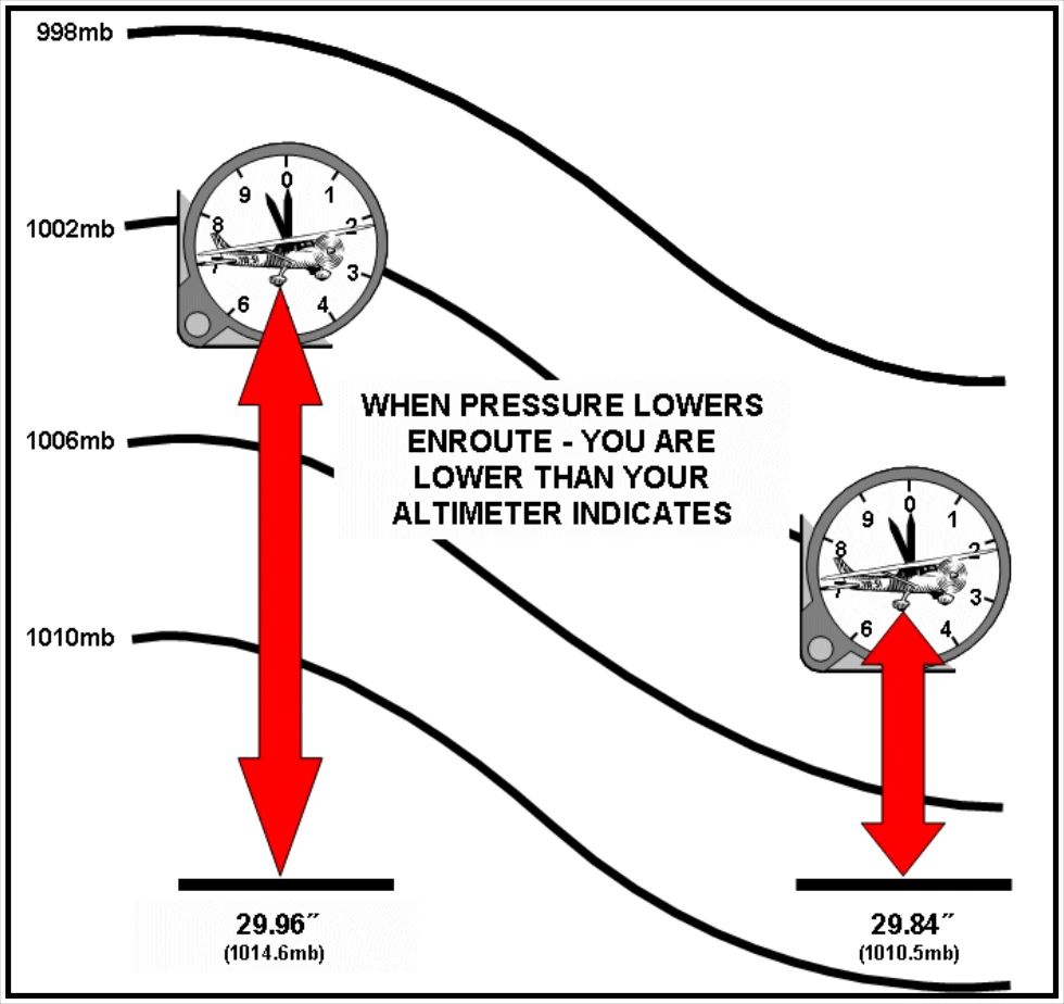
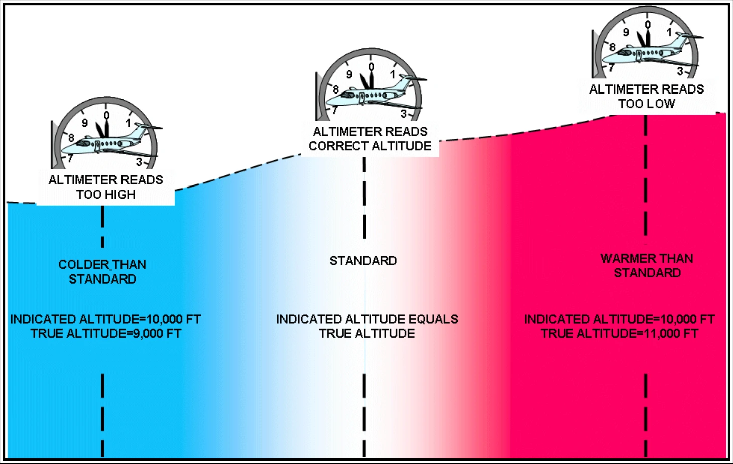
Figure 8-14 shows that as a pilot flies from warm to cold air, the altimeter reads too high—the pilot is lower than the altimeter indicates. Over flat terrain, this lower-than-true reading is no great problem; other aircraft in the vicinity are also flying indicated rather than true altitude, and everyone’s altimeter readings are compatible. If flying in cold weather over mountainous areas, however, a pilot needs to take this difference between indicated and true altitude into account. The pilot needs to know that the true altitude assures clearance of terrain and compute a correction to indicated altitude.
8.4.1.3 Corrected (Approximately True) Altitude
If a pilot could always determine the mean temperature of a column of air between the aircraft and the surface, flight computers would be designed to use this mean temperature in computing true altitude. However, the only guide a pilot has to temperature below is free air temperature at the pilot’s altitude. Therefore, the flight computer uses outside air temperature (OAT) to correct indicated altitude to approximately true altitude. The corrected (approximately true) altitude is indicated altitude corrected for the temperature of the air column below the aircraft, the correction being based on the estimated deviation of the existing temperature from standard atmosphere temperature. It is a close approximation to true altitude and is labeled true altitude on flight computers. It is close enough to true altitude to be used for terrain clearance, provided the pilot has the altimeter set to the value reported from a nearby reporting station.
8.4.1.4 Pressure Altitude
In the standard atmosphere, sea level pressure is 29.92 inHg (1,013.2 mb). Pressure decreases at a fixed rate upward through the standard atmosphere. Therefore, in the standard atmosphere, a given pressure exists at any specified altitude. Pressure altitude is the altitude (above MSL) shown by the altimeter when set to 29.92 inHg. In other words, it is the altitude associated with a specific pressure measured by the static port when the altimeter is set to 29.92. Since pressure is the same everywhere regardless of the specific pressure altitude, a constant-pressure surface defines a constant-pressure altitude. When a pilot flies a constant-pressure altitude, the pilot is flying a constant-pressure surface.
As discussed earlier, constant-pressure surfaces have different heights across them. Therefore, when flying at a specific pressure altitude (i.e., constant-pressure surface) a pilot’s true altitude will change with distance. However, since pressure altitudes are flown at or above FL180 (in the United States), a pilot will almost always be above the highest terrain features.
8.4.1.5 Density Altitude
Density altitude is the pressure altitude corrected for temperature deviations from the standard atmosphere. Density altitude bears the same relation to pressure altitude as true altitude does to indicated altitude.
Density altitude is indirectly related to atmospheric density; as air density increases, the density altitude decreases, and conversely, as air density decreases, the density altitude increases. Airports with higher field elevations (e.g., Denver) have lower pressure, lower density, and, therefore, higher density altitudes than airports with lower field elevations (e.g., New Orleans).
Density altitude equals field elevation during standard atmospheric conditions, but conditions are rarely standard. Density altitude is higher (lower) than standard at airports that report lower (higher) than standard pressures (e.g., 29.92 inHg) and/or higher (lower)-than-standard temperatures. Temperature is the most important factor, since temperature has the greatest effect on density horizontally in the atmosphere. On hot days, the air becomes less dense, causing high density altitudes. On cold days, the air is denser, causing lower density altitudes. Dewpoint (water vapor) is also a contributing factor, but its effects are generally negligible.