
Chapter 4
Approaches
High or Lack of Minimum Vectoring Altitudes (MVAs)
Considering the fact that most modern commercial and corporate aircraft are capable of direct, point-to-point flight, it is increasingly important for pilots to understand the limitations of ARTCC capabilities with regard to minimum altitudes. There are many airports that are below the coverage area of Center radar, and; therefore, off-route transitions into the approach environment may require that the aircraft be flown at a higher altitude than would be required for an on-route transition. In the Durango example, an airplane approaching from the northeast on a direct route to the Durango VOR may be restricted to a minimum IFR altitude (MIA) of 17,000 feet MSL due to unavailability of Center radar coverage in that area at lower altitudes. An arrival on V95 from the northeast would be able to descend to a minimum en route altitude (MEA) of 12,000 feet, allowing a shallower transition to the approach environment. An off-route arrival may necessitate a descent into holding in order to avoid an unstable approach to Durango.
Lack of Approach Control Terrain Advisories
Flight crews must understand that terrain clearance cannot be assured by ATC when aircraft are operating at altitudes that are not served by Center or approach radar. Recent National Transportation Safety Board (NTSB) investigations have identified several accidents that involved controlled flight into terrain (CFIT) by IFR rated and VFR pilots operating under visual flight conditions at night in remote areas. In many of these cases, the pilots were in contact with ATC at the time of the accident and receiving radar service. The pilots and controllers involved all appear to have been unaware that the aircraft were in danger. Increased altitude awareness and better preflight planning would likely have prevented all of these accidents. How can pilots avoid becoming involved in a CFIT accident?
CFIT accidents are best avoided through proper preflight planning.
- Terrain familiarization is critical to safe visual operations at night. Use sectional charts or other topographic references to ensure that your altitude safely clears terrain and obstructions all along your route.
- In remote areas, especially in overcast or moonless conditions, be aware that darkness may render visual avoidance of high terrain nearly impossible and that the absence of ground lights may result in loss of horizon reference.
- When planning a nighttime VFR flight, follow IFR practices, such as climbing on a known safe course, until well above surrounding terrain. Choose a cruising altitude that provides terrain separation similar to IFR flights (2,000 feet AGL in mountainous areas and 1,000 feet above the ground in other areas.)
- When receiving radar services, do not depend on ATC to warn you of terrain hazards. Although controllers try to warn pilots if they notice a hazardous situation, they may not always be able to recognize that a particular VFR aircraft is dangerously close to terrain.
- When issued a heading along with an instruction to “maintain VFR,” be aware that the heading may not provide adequate terrain clearance. If you have any doubt about your ability to visually avoid terrain and obstacles, advise ATC immediately and take action to reach a safe altitude if necessary.
- ATC radar software can provide limited prediction and warning of terrain hazards, but the warning system is configured to protect IFR flights and is normally suppressed for VFR aircraft. Controllers can activate the warning system for VFR flights upon pilot request, but it may produce numerous false alarms for aircraft operating below the MIA, especially in en route center airspace.
- If you fly at night, especially in remote or unlit areas, consider whether a GPS-based terrain awareness unit would improve your safety of flight.
- Lack of approach control traffic advisories—if radar service is not available for the approach, the ability of ATC to give flight crews accurate traffic advisories is greatly diminished. In some cases, the common traffic advisory frequency (CTAF) may be the only tool available to enhance an IFR flight’s awareness of traffic at the destination airport. Additionally, ATC will not clear an IFR flight for an approach until the preceding aircraft on the approach has cancelled IFR, either on the ground, or airborne once in visual meteorological conditions (VMC).
Airports With an ATC Tower
Control towers are responsible for the safe, orderly, and expeditious flow of all traffic that is landing, taking off, operating on and in the vicinity of an airport and, when the responsibility has been delegated, towers also provide for the separation of IFR aircraft in terminal areas. Aircraft that are departing IFR are integrated into the departure sequence by the tower. Prior to takeoff, the tower controller coordinates with departure control to assure adequate aircraft spacing.
Airports Without A Control Tower
From a communications standpoint, executing an instrument approach to an airport that is not served by an ATC tower requires more attention and care than making a visual approach to that airport. Pilots are expected to self-announce their arrival into the vicinity of the airport no later than 10 NM from the field. Depending on the weather, as well as the amount and type of conflicting traffic that exists in the area, an approach to an airport without an operating ATC tower increases the difficulty of the transition to visual flight.
In many cases, a flight arriving via an instrument approach needs to mix in with VFR traffic operating in the vicinity of the field. For this reason, many companies require that flight crews make contact with the arrival airport CTAF or company operations personnel via a secondary radio over 25 NM from the field in order to receive traffic advisories. In addition, pilots should attempt to listen to the CTAF well in advance of their arrival in order to determine the VFR traffic situation.
Since separation cannot be provided by ATC between IFR and VFR traffic when operating in areas where there is no radar coverage, pilots are expected to make radio announcements on the CTAF. These announcements allow other aircraft operating in the vicinity to plan their departures and arrivals with a minimum of conflicts. In addition, it is very important for crews to maintain a listening watch on the CTAF to increase their awareness of the current traffic situation. Flights inbound on an instrument approach to a field without a control tower should make several self-announced radio calls during the approach:
- Initial call within 4-10 minutes of the aircraft’s arrival at the IAF. This call should give the aircraft’s location as well as the crew’s approach intentions.
- Departing the IAF, stating the approach that is being initiated.
- Procedure turn (or equivalent) inbound.
- FAF inbound, stating intended landing runway and maneuvering direction if circling.
- Short final, giving traffic on the surface notification of imminent landing.
When operating on an IFR flight plan at an airport without a functioning control tower, pilots must initiate cancellation of the IFR flight plan with ATC or an AFSS. Remote communications outlets (RCOs) or ground communications outlets (GCOs), if available, can be used to contact an ARTCC or an AFSS after landing. If a frequency is not available on the ground, the pilot has the option to cancel IFR while in flight if VFR conditions can be maintained while in contact with ARTCC, as long as those conditions can be maintained until landing. Additionally, pilots can relay a message through another aircraft or contact flight service via telephone.
Primary NAVAID
Most conventional approach procedures are built around a primary final approach NAVAID; others, such as RNAV (GPS) approaches, are not. If a primary NAVAID exists for an approach, it should be included in the IAP briefing, set into the appropriate backup or active navigation radio, and positively identified at some point prior to being used for course guidance. Adequate thought should be given to the appropriate transition point for changing from FMS or other en route navigation over to the conventional navigation to be used on the approach. Specific company standards and procedures normally dictate when this changeover occurs; some carriers are authorized to use FMS course guidance throughout the approach, provided that an indication of the conventional navigation guidance is available and displayed. Many carriers, or specific carrier fleets, are required to change over from RNAV to conventional navigation prior to the FAF of an instrument approach.
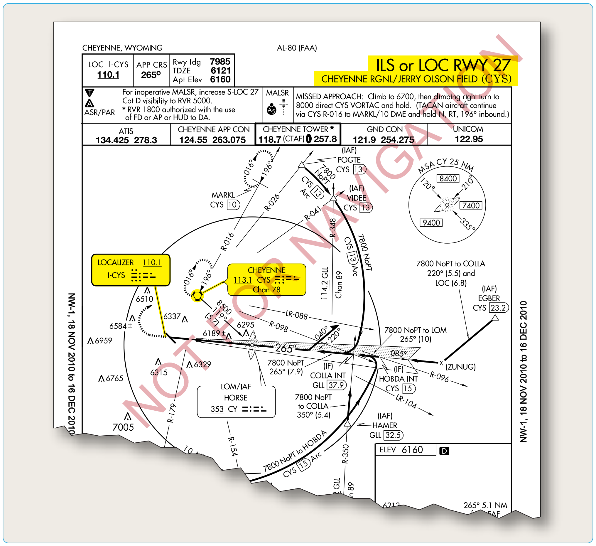
Depending on the complexity of the approach procedure, pilots may have to brief the transition from an initial NAVAID to the primary and missed approach NAVAIDs. Figure 4-8 shows the Cheyenne, Wyoming, ILS Runway 27 approach procedure, which requires additional consideration during an IAP briefing.
If the 15 DME arc of the CYS VOR is to be used as the transition to this ILS approach procedure, caution must be paid to the transition from en route navigation to the initial NAVAID and then to the primary NAVAID for the ILS approach. Planning when the transition to each of these NAVAIDs occurs may prevent the use of the incorrect NAVAID for course guidance during approaches where high pilot workloads already exist.