
Chapter 24
Observations
The WSR-88D employs scanning strategies in which the antenna automatically raises to higher and higher preset angles (or elevation scans) as it rotates. These elevation scans comprise a volume coverage pattern (VCP) that NWS forecasters utilize to help analyze the atmosphere around the radar. These different VCPs have varying numbers of elevation tilts and rotation speeds of the radar itself. Therefore, each VCP can provide a different perspective of the atmosphere. Once the radar sweeps through all elevation slices, a volume scan is complete. The WSR-88D radar can use several VCPs.
There are two main classes of VCPs, which are commonly referred to as Clear Air Mode and Precipitation Mode.
24.6.1.3.1 Clear Air Mode
In Clear Air Mode, the radar is in its most sensitive operation. The NWS uses Clear Air Mode when there is no rain within the range of the radar. This mode has the slowest antenna rotation rate, which permits the radar to sample the atmosphere longer. This slower sampling increases the radar’s sensitivity and ability to detect smaller objects in the atmosphere. The term “clear air” does not imply “no precipitation” mode. Even in Clear Air Mode, the WSR-88D can detect light, stratiform precipitation (e.g., snow) due to the increased sensitivity. Generally, the only returned energy to the radar will be very close to the radar’s location.
Many of the radar returns in Clear Air Mode are airborne dust and particulate matter. The WSR-88D images are updated approximately every 10 minutes when operating in this mode.
24.6.1.3.2 Precipitation Mode
Precipitation targets typically provide stronger return signals to the radar than non-precipitation targets. Therefore, the WSR-88D is operated in Precipitation Mode when precipitation is present, although some non-precipitation echoes can still be detected in this operating mode. The NWS uses Precipitation Mode to see higher into the atmosphere when precipitation is occurring to analyze the vertical structure of the storms.
The faster rotation of the WSR-88D in Precipitation Mode allows images to update at a faster rate, approximately every four to six minutes.
24.6.1.4 Echo Intensities
The colors on radar images represent the reflective power of the precipitation target. In general, the amount of radar power received is proportional to the intensity of the precipitation. This reflective power, commonly referred to by meteorologists as “reflectivity,” is measured in terms of dBZ. A decibel is a unit that describes the change of power emitted versus the power received. Since the power emitted is constant, the power received is related to the intensity of the precipitation target. Each reflectivity image includes a color scale that describes the relationship among reflectivity value, color on the radar image, and precipitation intensity (see Figure 24-11). The color scale and decibel scale can vary depending on the service provider and website.
Reflectivity is correlated to intensity of precipitation. For example, in Precipitation Mode, when the decibel value reaches 15, light precipitation is present. The higher the indicated reflectivity value, the higher the rainfall rate. The interpretation of reflectivity values is the same for both Clear Air and Precipitation Modes.

Reflectivity is also correlated with intensity terminology (phraseology) for ATC purposes. Table 24-8 defines this correlation.
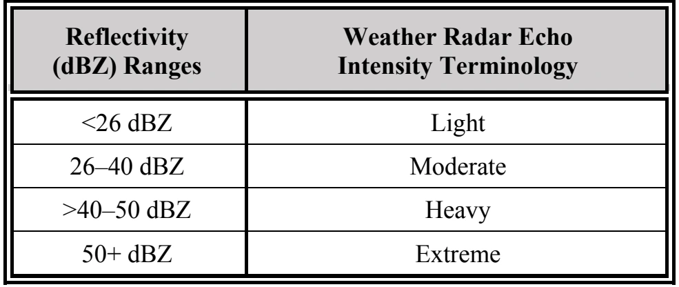
Values below 15 dBZ are typically associated with clouds. However, they may also be caused by atmospheric particulate matter such as dust, insects, pollen, or other phenomena. The scale cannot reliably be used to determine the intensity of snowfall. However, snowfall rates generally increase with increasing reflectivity.
24.6.1.5 Radar Products
The NWS produces many radar products that serve a variety of users. Some of these products are of interest to the aviation community. This section will discuss radar mosaics, Composite Reflectivity, Base Reflectivity, and Echo Tops products.
24.6.1.5.1 Radar Mosaic
A radar mosaic consists of multiple single-site radar images combined to produce a radar image on a regional or national scale. Radar mosaics can be found on the websites of the NWS, AWC, and all NWS WFOs, as well as commercial aviation weather providers. Radar mosaics can be assembled from Composite Reflectivity, Base Reflectivity, and Echo Tops, depending on the website or data provider.