Chapter 27
Forecasts
FAs containing errors will be corrected. COR is included after the date/time group.
27.6.4 Alaska FA
27.6.4.1 Alaska FA Issuance
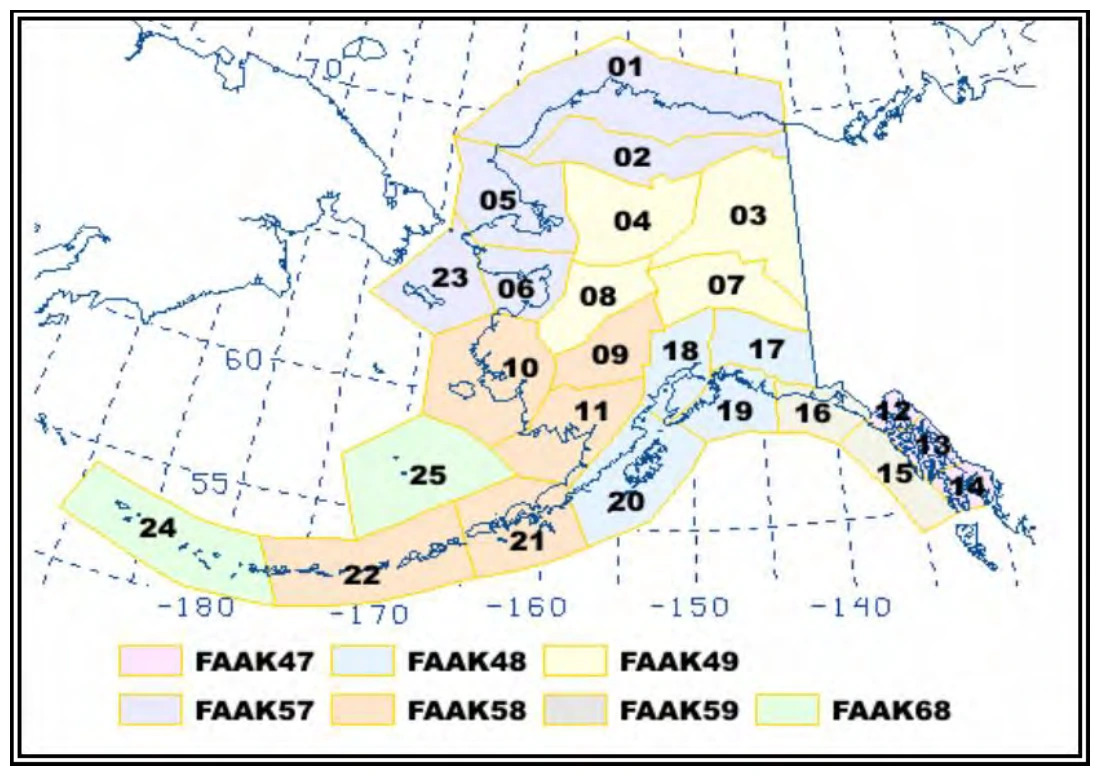
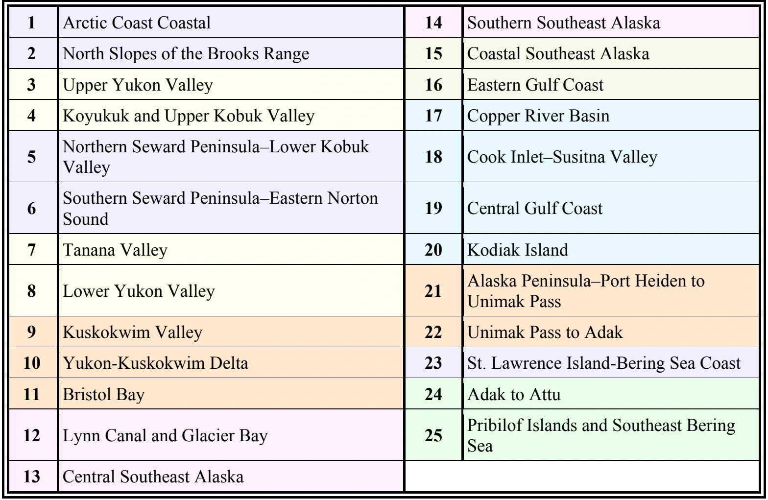
Issued by the AAWU. There are seven FAs containing a total of 25 zones (see Table 27-9), covering separate geographical areas of Alaska and the adjacent coastal waters, including the Pribilof Islands and Southeast Bering Sea (see Figure 27-3).
FAs issued for Alaska cover the airspace between the surface and 45,000 ft MSL and include the following elements:
- Synopsis: A brief description of the significant synoptic weather affecting the FA area during the first 18 hours of the forecast period.
- Significant Clouds and Weather: A description of the significant clouds and weather for each geographical zone during the first 12 hours of the forecast period, including the following elements:
- AIRMET information for IFR ceiling and visibility, mountain obscuration, and strong surface winds.
- Cloud amount (SCT, BKN, or OVC) with bases and tops.
- Visibility below 7 SM and obstruction(s) to visibility.
- Precipitation and thunderstorms.
- Surface wind greater than 20 kt.
- Mountain pass conditions using categorical terms (for selected zones only).
- Categorical outlook (VFR, MVFR, and IFR) for 12 to 18 hours.
- Icing and Freezing Level: A description of expected icing conditions, including the following elements:
- AIRMET information for icing and freezing precipitation.
- Icing not meeting SIGMET or AIRMET criteria during the six-hour to 12-hour period.
- Freezing level.
- If no significant icing is forecast, NIL SIG will be entered, followed by the freezing level.
- Turbulence: A description of expected turbulence conditions, including the following elements:
- AIRMET information for turbulence or LLWS.
- Turbulence not meeting SIGMET or AIRMET criteria during the six-hour to 12-hour period.
- If no significant turbulence is forecast, NIL SIG will be entered.
27.6.4.2 FA—Alaska Example
FAAK47 PAWU 222010 (ICAO product header)
FA7H (NWS AWIPS Communication header)
JNUH FA 222015 (Area Forecast region, product type, issuance date/time)
EASTERN GULF COAST AND SE AK...
.
AIRMETS VALID UNTIL 230415
CB IMPLY POSSIBLE SEV OR GREATER TURB SEV ICE LLWS AND IFR CONDS.
NON MSL HEIGHTS NOTED BY AGL OR CIG.
.
SYNOPSIS VALID UNTIL 231400
989 MB LOW 275 NM SE KODIAK IS WILL MOV SE WARD TO ABOUT 350 NM S
PASI BY 14Z WHILE FILLING TO 998 MB. ASSOCD OCFNT ARCING E AND SE FM
LOW WILL MOV ONSHR SE AK AND DSIPT BY END OF PD.
.
LYNN CANAL AND GLACIER BAY JB...VALID UNTIL 230800
...CLOUDS/WX...
FEW025 SCT050 BKN100 TOP 120.
OTLK VALID 230800-231400...VFR.
PASSES...WHITE...CHILKOOT...VFR.
...TURB...
NIL SIG.
...ICE AND FZLVL...
NIL SIG. FZLVL 020.
.
CNTRL SE AK JC...VALID UNTIL 230800
...CLOUDS/WX...
FEW025 SCT050 BKN100 TOP 120.
AFT 03Z ISOL BKN050 -SHRA.
OTLK VALID 230800-231400...VFR.
...TURB...
AFT 05Z SW PAFE ISOL MOD TURB BLW 040.
...ICE AND FZLVL...
NIL SIG. FZLVL 025.
.
SRN SE AK JD...VALID UNTIL 230800
...CLOUDS/WX...
FEW025 SCT050 BKN100 TOP 120.
AFT 00Z OCNL BKN050 -RA. ISOL BKN025 -RA.
AFT 03Z SFC WND SE 25G35KT.
OTLK VALID 230800-231400...VFR.
...TURB...
AFT 02Z CLARENCE STRAIT SW ISOL MOD TURB BLW 040.
...ICE AND FZLVL...
AFT 02Z OUTER CST PAHY S ISOL MOD ICEIC 040-100. FZLVL 025.
27.7 Alaska Graphical Forecasts
The NWS AAWU produces a series of graphical forecasts to complement the text-based FA for Alaska (see Section 27.6.4.1). These forecasts are available from the AAWU’s website. Forecasts include:
- Flying Weather,
- Surface Forecast,
- Icing Forecast,
- Turbulence Forecast, and
- Convective Outlook (seasonal product and only issued from May 1 through September 30).
Additional products may be available. Some of these may be labeled experimental; thus, the contents and format are subject to change.
27.7.1 AAWU Flying Weather
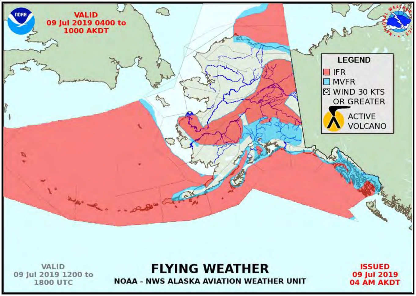
The Flying Weather graphic (see Figure 27-4) includes flying weather conditions and any active volcanoes in Alaska. This product consists of two six-hour forecasts valid for a total of 12 hours. Each forecast specifies where such conditions can be expected within the six-hour valid time.
Areas of occasional or continuous MVFR/IFR are represented by shaded regions (red for IFR, blue for MVFR), whereas areas of predominately VFR weather are not shaded. MVFR/IFR conditions are possible outside these shaded regions, but only isolated in coverage. Strong surface winds are shown in a circle hatch overlay. Active volcanoes are denoted by a volcano symbol at the location of the volcano.