
Chapter 27
Forecasts
27.17.1 Convective Outlook (AC)
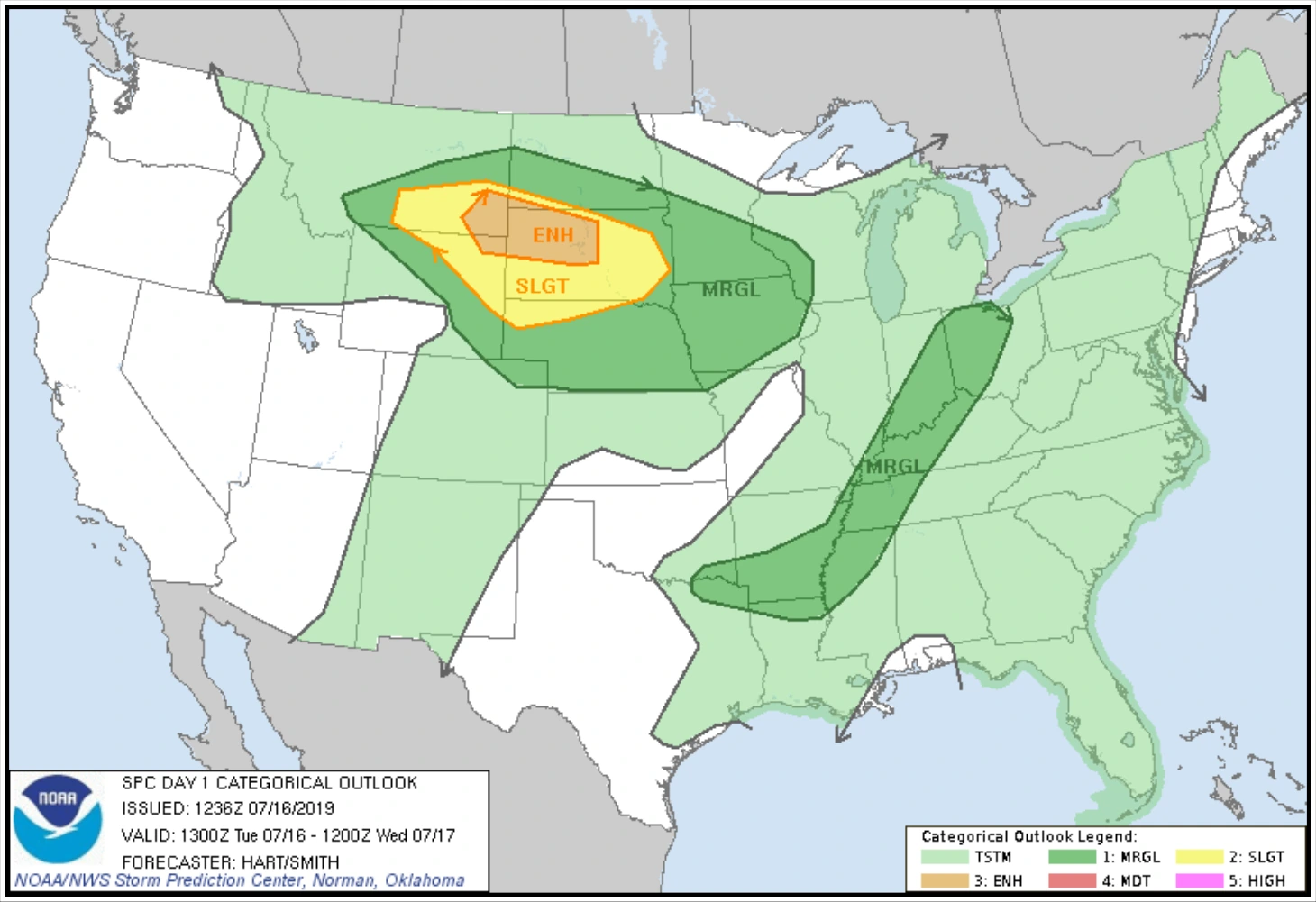
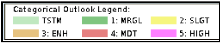
The NWS SPC issues narrative and graphical Convective Outlooks (AC) to provide the CONUS NWS WFOs, the public, the media, and emergency managers with the potential for severe (tornado, wind gusts 50 kt or greater, or hail with diameter one inch or greater) and non-severe (general) convection and specific severe weather threats during the following eight days. The Convective Outlook defines areas of marginal risk (MRGL), slight risk (SLGT), enhanced risk (ENH), moderate risk (MDT), or high risk (HIGH) of severe weather based on a percentage probability, which varies for time periods from one day to three days, and then two probabilistic thresholds for days four through eight. The day one, day two, and day three Convective Outlooks also depict areas of general thunderstorms (TSTM). The outlooks in graphical (see Figure 27-28) and text formats are available on the SPC’s website. See Figure 27-29 for the legend.
27.17.2 Traffic Flow Management (TFM) Convective Forecast (TCF)
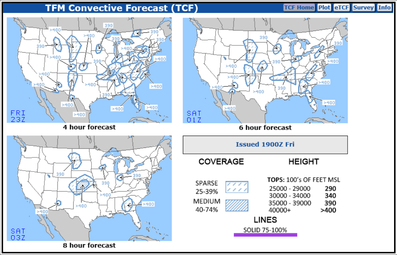
The TCF is a high-confidence graphical representation of forecasted convection meeting specific criteria of coverage, intensity, and echo top height. The TCF graphics are produced every two hours and are valid at four, six, and eight hours after issuance time.
Areas of convection in the TCF include any area of convective cells meeting the following criteria (at a minimum):
- Composite radar reflectivity of at least 40 dBZ;
- Echo tops at or above FL250;
- Coverage (criteria 1 and 2) of at least 25 percent of the polygon area; and
- Forecaster confidence of at least 50 percent (high) that criteria 1, 2, and 3 will be met.
Lines of convection in the TCF include any lines of convective cells meeting the following criteria (at a minimum):
- Composite radar reflectivity of at least 40 dBZ having a length of at least 100 NM;
- Linear coverage of 75 percent or greater;
- Echo tops at or above FL250; and
- Forecaster confidence of at least 50 percent (high) that criteria 1, 2, and 3 will be met.
All four of the threshold criteria listed above for both areas and lines of convection are necessary for inclusion in the TCF. This is defined as the minimum TCF criteria. The TCF does not include a forecast for all convection. If the convection does not meet the threshold criteria, it is not included in the TCF.
The TCF domain is the FIR covering the CONUS and adjacent coastal waters. It also includes the Canadian airspace south of a line from Thunder Bay, Ontario, to Quebec City, Quebec.
From March 1 through October 31, the TCF is collaboratively produced by meteorologists at the AWC in Kansas City, MO, and embedded at the FAA ATCSCC in Warrenton, VA; at the CWSU embedded at the FAA’s ARTCC; at various airlines; and by other authorized participants. Automated routines will continue to make the TCF available from November 1 through February 28.
The TCF is issued 24 hours a day, seven days a week at 30 minutes prior to the indicated issuance time. The issuance time supports the FAA’s Strategic Planning Webinar, which occurs 15 minutes following odd hours Eastern Time. The Canadian portion of the forecast is available from April 1 through September 30. However, NAV CANADA may request the issuance of each forecast as early as March 1 and as late as October 31. All available Canadian forecasts are incorporated into the TCF. During times the forecasts are not available for Canadian airspace, the TCF graphics will be annotated with “No Canadian TCF.” The graphical representation is subject to annual revision.
The AWC also produces an Extended TCF that provides TCFs from 10 to 30 hours at two-hour increments.
The TCF and Extended TCF is used by air traffic management decisionmakers in support of convective weather mitigation strategies within the NAS. It is designed to meet the needs of TFM decisionmakers at the FAA’s ATCSCC, the FAA’s ARTCC TMUs, and airline and corporate flight operations centers (FOC).
Figure 27-30 shows an example of a TCF.
27.17.3 Extended Convective Forecast Product (ECFP)
The ECFP planning tool (see Figure 27-31) is a graphical representation of the forecast probability of thunderstorms and is intended to support the long-range planning for convective constraints in the NAS. The product identifies graphically where thunderstorms are expected through the next 72 hours over the CONUS. Although the ECFP uses TCF-style graphics to facilitate ease of interpretation, the ECFP does not forecast TCF criteria.