Chapter 27
Forecasts
27.17.4.2 Public Severe Thunderstorm Watch Notification Message
The SPC issues a Public Severe Thunderstorm Watch Notification Message when forecasting six or more hail events of one inch (quarter-sized) diameter or greater or damaging winds of 50 kt (58 mph) or greater. The forecast event minimum threshold is at least two hours over an area of at least 8,000 mi2. Below these thresholds, the SPC, in collaboration with affected NWS offices, may issue a watch for smaller areas and for shorter periods of time when conditions warrant, and for convective watches along coastlines, near the Canadian border, and near the Mexican border.
A Public Severe Thunderstorm Watch Notification Message contains three bulleted blocks of information:
- The geographic area of the watch,
- The valid time of the watch, and
- A description of the primary threats anticipated within the watch.
A plain text watch summary is included beneath the bulleted information followed by a more detailed description of the area and axis of the watch.
The SPC includes the term “adjacent coastal waters” when the watch affects coastal waters adjacent to the Pacific/Atlantic coast, the Gulf of America, or the Great Lakes. Adjacent coastal waters refers to a WFO’s near-shore responsibility (out to 20 NM for oceans), except for convective watches.
The SPC issues a watch cancellation message when no counties, parishes, independent cities, and/or marine zones remaining are in the watch area prior to the expiration time. The text of the message will specify the number and area of the cancelled watch.
27.17.4.3 Public Tornado Watch Notification Message
The SPC issues a Public Tornado Watch Notification Message when forecasting two or more tornadoes or any tornado that could produce EF-2 or greater damage. The forecast event minimum thresholds are at least two hours over an area at least 8,000 mi2. Below these thresholds, the SPC, in collaboration with affected NWS offices, may issue a watch for smaller areas and for shorter periods of time when conditions warrant, and for convective watches along coastlines, near the Canadian border, and near the Mexican border.
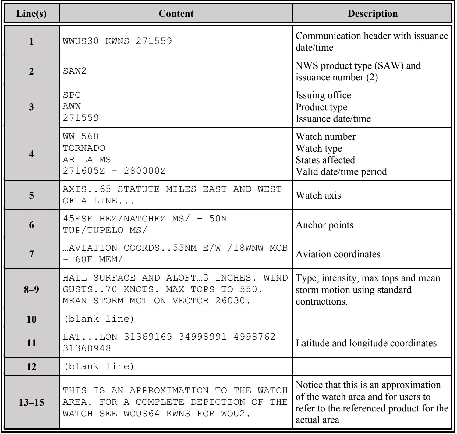
A Public Tornado Watch Notification Message contains the following:
- The area description and axis,
- The watch expiration time,
- The term “damaging tornadoes,”
- A description of the largest hail size and strongest thunderstorm wind gusts expected,
- The definition of the watch,
- A call-to-action statement,
- A list of other valid watches,
- A brief discussion of meteorological reasoning, and
- Technical information for the aviation community.
The SPC may enhance a Public Tornado Watch Notification Message by using the words “THIS IS A PARTICULARLY DANGEROUS SITUATION” when there is a likelihood of multiple strong (damage of EF-2 or EF-3) or violent (damage of EF-4 or EF-5) tornadoes.
The SPC includes the term “adjacent coastal waters” when the watch affects coastal waters adjacent to the Pacific/Atlantic coast or the Gulf of America. Adjacent coastal waters refers to a WFO’s near-shore responsibility (out to 20 NM for oceans), which includes portions of the Great Lakes.
The SPC issues a watch cancellation message whenever it cancels a watch prior to the expiration time. The text of the message will specify the number and area of the cancelled watch.
27.17.5 Corridor Integrated Weather System (CIWS) and Consolidated Storm Prediction for Aviation (CoSPA)
The CIWS and CoSPA are fully automated weather analysis and forecast systems developed for the FAA by the Massachusetts Institute of Technology (MIT) Lincoln Laboratory. These systems combine data from a wide variety of weather radars, satellites, surface observations, and numerical models to provide accurate, rapidly updating weather information to air traffic controllers, air traffic flow managers, and airline users. The state-of-the-art weather products allow managers to achieve more efficient tactical and strategic use of the airspace, reduce controller workload, and significantly reduce delays.
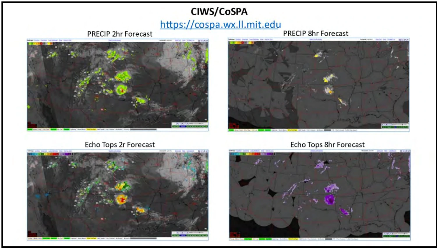
The CIWS provides deterministic zero- to two-hour forecasts of precipitation, winter precipitation, and echo tops. The deterministic forecast portrays storms in the same format as a radar detection. Thus, the deterministic forecast is sometimes referred to as a “radar forward” depiction. The forecasts are provided as gridded maps or contour overlays on the current weather. An animated loop is available with two hours of past weather and forecasts out to two hours in the future, with five-minute granularity. This forecast granularity can be set to five minutes, 10 minutes, 15 minutes, 30 minutes, or one hour, depending on the user’s needs.
CoSPA provides deterministic zero- to eight-hr forecasts of precipitation, winter precipitation, and echo tops. The animated loop allows the display of eight hours of past weather and forecasts out to eight hours in the future, with 15-minute granularity that can be set to 15 minutes, 30 minutes, or one hour. The first two hours of the CoSPA forecasts are identical to the CIWS forecasts.