
Chapter 1
Departure Procedures
Another set of lower-than-standard takeoff minimums is available to Part 121 and Part 135 operations as outlined in their respective OpSpecs document. When certain types of visibility reports are unavailable or specific equipment is out of service, the flight can still depart the airport if the pilot can maintain adequate visual reference. An appropriate visual aid must be available to ensure the takeoff surface can be continuously identified, and directional control can be maintained throughout the takeoff run. Appropriate visual aids include high intensity runway lights, runway centerline lights, runway centerline markings, or other runway lighting and markings. With adequate visual references and appropriate OpSpec approval, commercial operators may take off with a visibility of 1600 RVR or ¼ SM.
Ceilings
Ceiling is the height above the earth’s surface of the lowest layer of clouds or obscuring phenomena that is reported as broken, overcast, or obscuration and not classified as thin or partial.
Automated Weather Systems
An automated weather system consists of any of the automated weather sensor platforms that collect weather data at airports and disseminate the weather information via radio and/or landline. The systems consist of the ASOS/Automated Weather Sensor System (AWSS) and the AWOS.
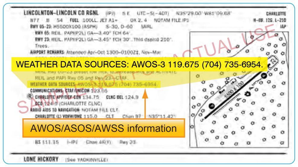
These systems are installed and maintained at airports across the United States by both government (FAA and National Weather Service (NWS)) and private entities. They are relatively inexpensive to operate because they require no outside observer, and they provide invaluable weather information for airports without operating control towers. [Figure 1-11]
AWOS and ASOS/AWSS offer a wide variety of capabilities and progressively broader weather reports. Automated systems typically transmit weather every one to two minutes so the most up-to-date weather information is constantly broadcast. Basic AWOS includes only altimeter setting, wind speed, wind direction, temperature, and dew point information. More advanced systems, such as the ASOS/AWSS and AWOS-3, are able to provide additional information, such as wind speed, wind gust, wind direction, variable wind direction, temperature, dew point, altimeter setting, and density altitude. ASOS/AWSS stations providing service levels A or B also report RVR. The specific type of equipment found at a given facility is listed in the CS. [Figure 1-12]
The use of the aforementioned visibility reports and weather services are not limited for Part 91 operators. Part 121 and 135 operators are bound by their individual OpSpecs documents and are required to use weather reports that come from the NWS or other approved sources. While every operator’s specifications are individually tailored, most operators are required to use ATIS, RVR reports, and selected reports from automated weather stations. All reports coming from an AWOS-3 station are usable for Part 121 and Part 135 operators. Each type of automated station has different levels of approval as outlined in individual OpSpecs. Ceiling and visibility reports given by the tower with the departure information are always considered official weather, and RVR reports are typically the controlling visibility reference.
Automatic Terminal Information Service (ATIS)
ATIS is another valuable tool for gaining weather information. ATIS is available at most airports that have an operating control tower, which means the reports on the ATIS frequency are only available during the regular hours of tower operation. At some airports that operate part-time towers, ASOS/AWSS information is broadcast over the ATIS frequency when the tower is closed. This service is available only at those airports that have both an ASOS/AWSS on the field and an ATIS-ASOS/AWSS interface switch installed in the tower.
Each ATIS report includes crucial information about runways and instrument approaches in use, specific outages, and current weather conditions including visibility. Visibility is reported in statute miles and may be omitted if the visibility is greater than five miles. ATIS weather information comes from a variety of sources depending on the particular airport and the equipment installed there. The reported weather may come from a manual weather observer, weather instruments located in the tower, or from automated weather stations. This information, no matter the origin, must be from NWS approved weather sources for it to be used in the ATIS report.
Digital Automatic Terminal Information Service (D-ATIS)
The digital ATIS (D-ATIS) is an alternative method of receiving ATIS reports. The service provides text messages to aircraft, airlines, and other users outside the standard reception range of conventional ATIS via landline and data link communications to the flight deck. Aircraft equipped with data link services are capable of receiving ATIS information over their Aircraft Communications Addressing and Reporting System (ACARS) unit. This allows the pilots to read and print out the ATIS report inside the aircraft, thereby increasing report accuracy and decreasing pilot workload.
Also, the service provides a computer-synthesized voice message that can be transmitted to all aircraft within range of existing transmitters. The Terminal Data Link System (TDLS) D-ATIS application uses weather inputs from local automated weather sources or manually entered meteorological data together with preprogrammed menus to provide standard information to users. Airports with D-ATIS capability are listed in the CS.
It is important to remember that ATIS information is updated hourly and anytime a significant change in the weather occurs. As a result, the information is not the most current report available. Prior to departing the airport, you need to get the latest weather information from the tower. ASOS/AWSS and AWOS also provide a source of current weather, but their information should not be substituted for weather reports from the tower.
IFR Alternate Requirements
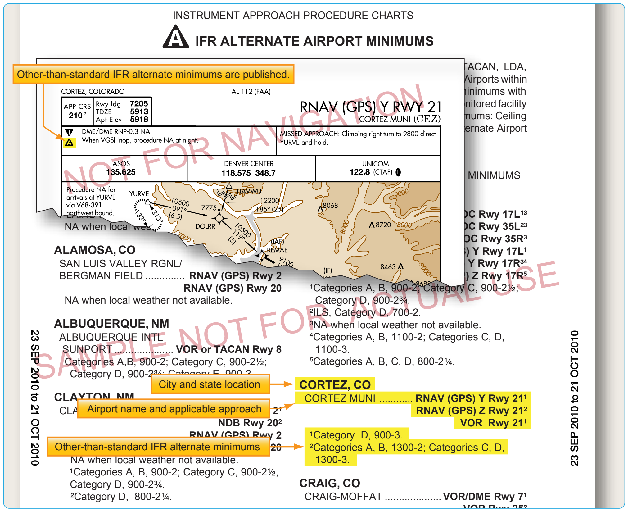
On Aeronautical Information Services charts, standard alternate minimums are not published. If the airport has other than standard alternate minimums, they are listed in the front of the approach chart booklet. The presence of a triangle with an A on the approach chart indicates the listing of alternate minimums should be consulted. Airports that do not qualify for use as an alternate airport are designated with an A N/A. [Figure 1-13] The requirement for an alternate depends on the aircraft category, equipment installed, approach navigational aid (NAVAID), and forecast weather. For example, airports with only a global positioning system (GPS) approach procedure cannot be used as an alternate by TSO-C129 or C196 users unless certain requirements are met (see AIM) even though the "N/A" has been removed from the approach chart. For select area navigation (RNAV) GPS and GPS approach procedures, the "N/A" is being removed so they may be used as an alternate by aircraft equipped with an approach-approved Wide Area Augmentation System (WAAS) receiver complaying with (TSO-C145 or C146) or TSO-C129 or C196 meeitng certain requirements (see AIM). Because GPS is not authorized as a substitute means of navigation guidance when conducting a conventional approach at an alternate airport, if the approach procedure requires either distance measuring equipment (DME) or automatic direction finder (ADF), the aircraft must be equipped with the appropriate DME or ADF avionics in order to use the approach as an alternate.
For aircraft other than helicopters, 14 CFR Part 91 requirements, an alternate airport must be listed on IFR flight plans if the forecast weather at the destination airport, for at least one hour before and for one hour after the estimated time of arrival (ETA), the ceiling is less than 2,000 feet above the airport elevation, and the visibility is less than 3 SM. One way to remember the rules for determining the necessity of filing an alternate is the “1, 2, 3 Rule.” For helicopters, similar alternate filing requirements in 14 CFR Part 91 apply. An alternate must be listed on an IFR flight plan if at the ETA and for one hour after the ETA, the ceiling is at least 1,000 feet above the airport elevation, or at least 400 feet above the lowest applicable approach minima, whichever is higher, and the visibility is at least 2 SM.