
Chapter 2
En Route Operations
Random RNAV routes are direct routes that are based on RNAV capability between waypoints defined in terms of latitude or longitude coordinates, degree-distance fixes, or offsets from established routes or airways at a specified distance and direction. Radar monitoring by ATC is required on all random RNAV routes. Random RNAV routes can only be approved in a radar environment. Factors that are considered by ATC when approving random RNAV routes include the capability to provide radar monitoring and compatibility with traffic volume and flow. ATC radar monitor each flight; however, navigation on the random RNAV route is the responsibility of the pilot.
Pilots flying aircraft that are equipped with approved area navigation equipment may file for RNAV routes throughout the NAS and may be filed for in accordance with the following procedures:
- File airport-to-airport flight plans.
- File the appropriate RNAV capability certification suffix in the flight plan.
- Plan the random route portion of the flight plan to begin and end over appropriate arrival and departure transition fixes or appropriate NAVAIDs for the altitude stratum within which the flight is conducted. The use of normal preferred DPs and STAR, where established, is recommended.
- File route structure transitions to and from the random route portion of the flight.
- Define the random route by waypoints. File route description waypoints by using degree distance fixes based on navigational aids that are appropriate for the altitude stratum.
- File a minimum of one route description waypoint for each ARTCC through whose area the random route is flown. These waypoints must be located within 200 NM of the preceding center’s boundary.
- File an additional route description waypoint for each turnpoint in the route.
- Plan additional route description waypoints as required to ensure accurate navigation via the filed route of flight. Navigation is the pilot’s responsibility unless ATC assistance is requested.
- Plan the route of flight so as to avoid prohibited and restricted airspace by 3 NM unless permission has been obtained to operate in that airspace and the appropriate ATC facilities are advised.
Pilots flying aircraft that are equipped with latitude/longitude coordinate navigation capability, independent of VOR/ TACAN references, may file for random RNAV routes at and above FL 390 within the conterminous United States using the following procedures:
- File airport-to-airport flight plans prior to departure.
- File the appropriate RNAV capability certification suffix in the flight plan.
- Plan the random route portion of the flight to begin and end over published departure/arrival transition fixes or appropriate NAVAIDs for airports without published transition procedures. The use of preferred departure and arrival routes, such as DP and STAR where established, is recommended.
- Plan the route of flight so as to avoid prohibited and restricted airspace by 3 NM unless permission has been obtained to operate in that airspace and the appropriate ATC facility is advised.
- Define the route of flight after the departure fix, including each intermediate fix (turnpoint) and the arrival fix for the destination airport in terms of latitude/longitude coordinates plotted to the nearest minute or in terms of Navigation Reference System (NRS) waypoints. For latitude/longitude filing, the arrival fix must be identified by both the latitude/ longitude coordinates and a fix identifier as shown in the example below.
MIA1 SRQ2 3407/106153 3407/11546 TNP4 LAX5 1Departure airport 2Departure fix 3Intermediate fix (turning point) 4Arrival fix 5Destination airport
Or:
ORD1 IOW2 KP49G3 KD34U4 KL16O5 OAL6 MOD27 SFO8 1Departure airport 2Transition fix (pitch point) 3Minneapolis ARTCC waypoint 4Denver ARTCC waypoint 5Los Angeles ARTCC waypoint (catch point) 6Transition fix 7Arrival 8Destination airport
- Record latitude/longitude coordinates by four figures describing latitude in degrees and minutes followed by a solidus and five figures describing longitude in degrees and minutes.
- File at FL 390 or above for the random RNAV portion of the flight.
- Fly all routes/route segments on Great Circle tracks.
- Make any in-flight requests for random RNAV clearances or route amendments to an en route ATC facility.
Off-Airway Routes
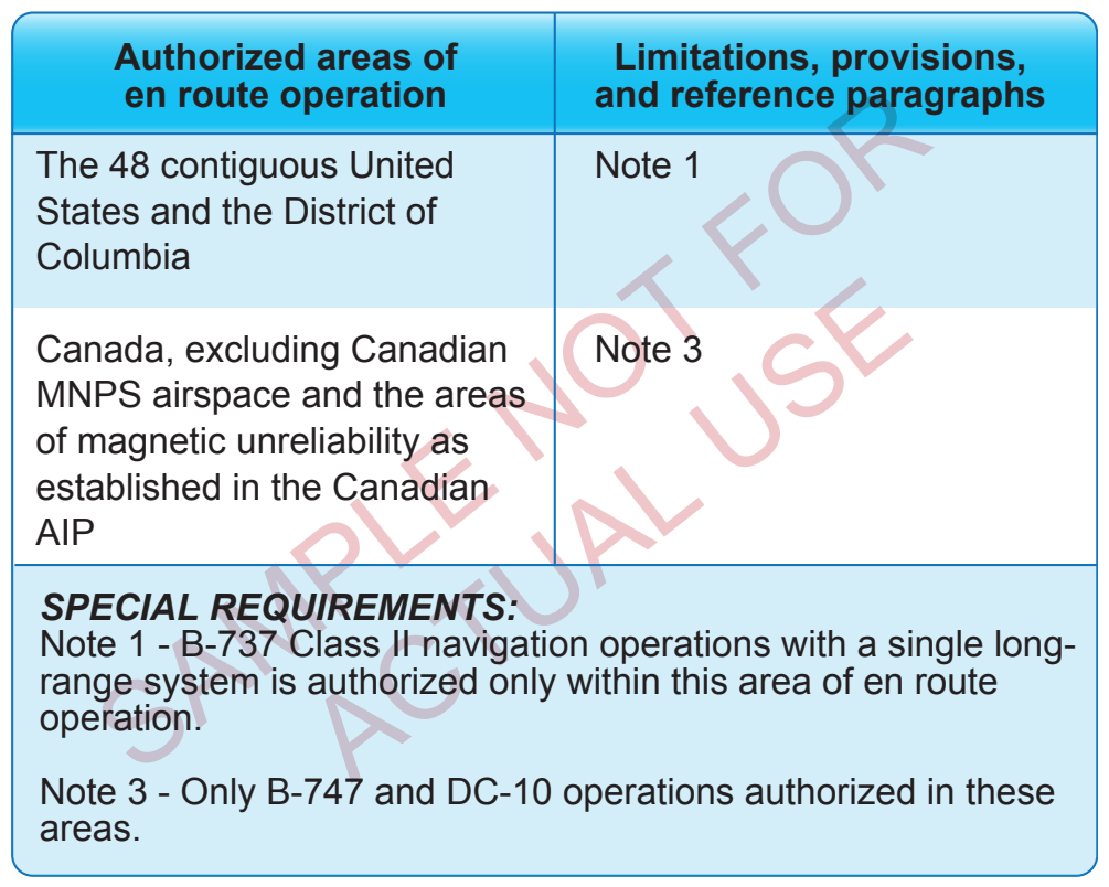
14 CFR Part 95 prescribes altitudes governing the operation of aircraft under IFR on Federal airways, jet routes, RNAV low or high altitude routes, and other direct routes for which a MEA is designated. In addition, it designates mountainous areas and COPs. Off-airway routes are established in the same manner and in accordance with the same criteria as airways and jet routes. If a pilot flies for a scheduled air carrier or operator for compensation or hire, any requests for the establishment of off-airway routes are initiated by the company through the principal operations inspector (POI) who works directly with the company and coordinates FAA approval. Air carrier authorized routes should be contained in the company’s Operations Specifications (OpSpecs) under the auspices of the air carrier operating certificate. [Figure 2-46]
Off-airway routes predicated on public navigation facilities and wholly contained within controlled airspace are published as direct Part 95 routes. Off-airway routes predicated on privately owned navigation facilities or not contained wholly within controlled airspace are published as off-airway non-Part 95 routes. In evaluating the adequacy of off-airway routes, the following items are considered: the type of aircraft and navigation systems used; proximity to military bases, training areas, low level military routes; and the adequacy of communications along the route.
Commercial operators planning to fly off-airway routes should have specific instructions in the company’s OpSpecs that address en route limitations and provisions regarding en route authorizations to use the GPS or other RNAV systems in the NAS. The company’s manuals and checklists should include practices and procedures for long-range navigation and training on the use of long range navigation equipment. Minimum equipment lists (MELs) and maintenance programs must address the long range navigation equipment. Examples of other selected areas requiring specialized en route authorization include the following:
- Class I navigation in the United States Class A airspace using area of long range navigation system.
- Class II navigation using multiple long range navigation systems.
- Operations in central East Pacific airspace.
- North Pacific operations.
- Operations within North Atlantic (NAT) minimum navigation performance specifications (MNPS) airspace.
- Operations in areas of magnetic unreliability.
- North Atlantic operation (NAT/OPS) with two engine aircraft under 14 CFR Part 121.
- Extended range operations (ER-OPS) with two engine aircraft under 14 CFR Part 121.
- Special fuel reserves in international operations.
- Planned in-flight re-dispatch or re-release en route.
- Extended over water operations using a single long-range communication system.
- Operations in reduced vertical separation minimum (RVSM) airspace.
Off-Route Obstruction Clearance Altitude
An off-route obstruction clearance altitude (OROCA) is or communications coverage. OROCAs are intended primarily as a pilot tool for emergencies and SA. OROCAs depicted on en route charts do not provide the pilot with an acceptable altitude for terrain and obstruction clearance for the purposes of off-route, random RNAV direct flights in either controlled or uncontrolled airspace. OROCAs are not subject to the same scrutiny as MEAs, minimum vectoring altitude (MVAs), MOCAs, and other minimum IFR altitudes. Since they do not undergo the same obstruction evaluation, airport airspace analysis procedures, or flight inspection, they cannot provide the same level of confidence as the other minimum IFR altitudes.